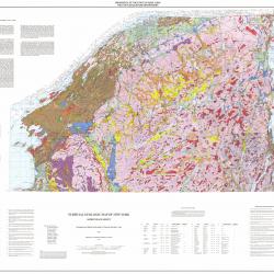
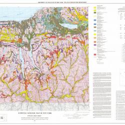
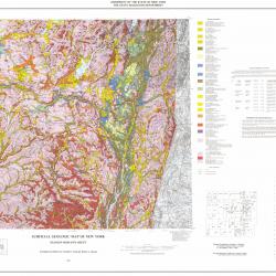
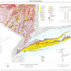
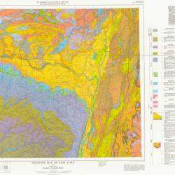
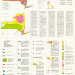
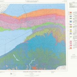
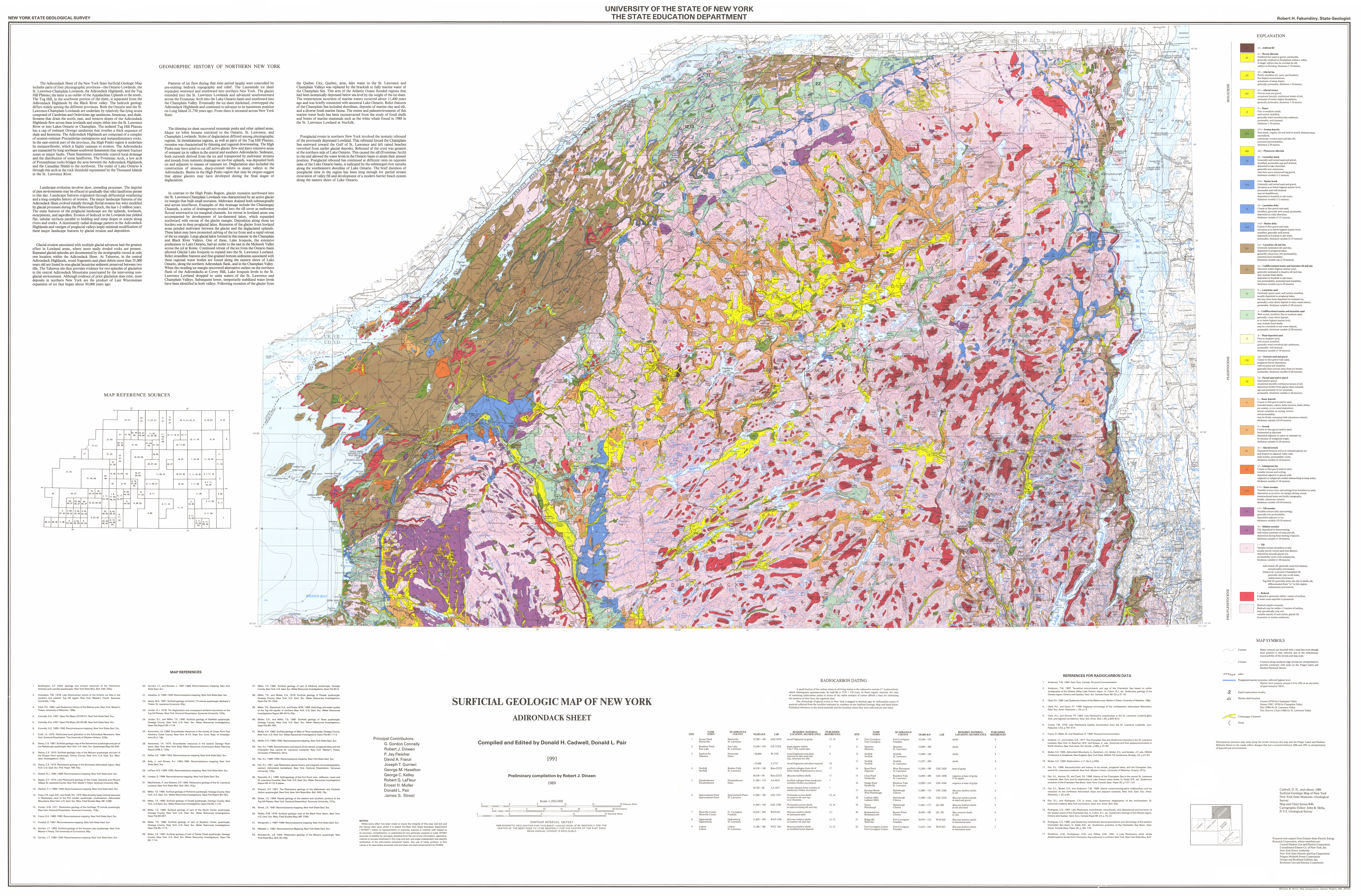
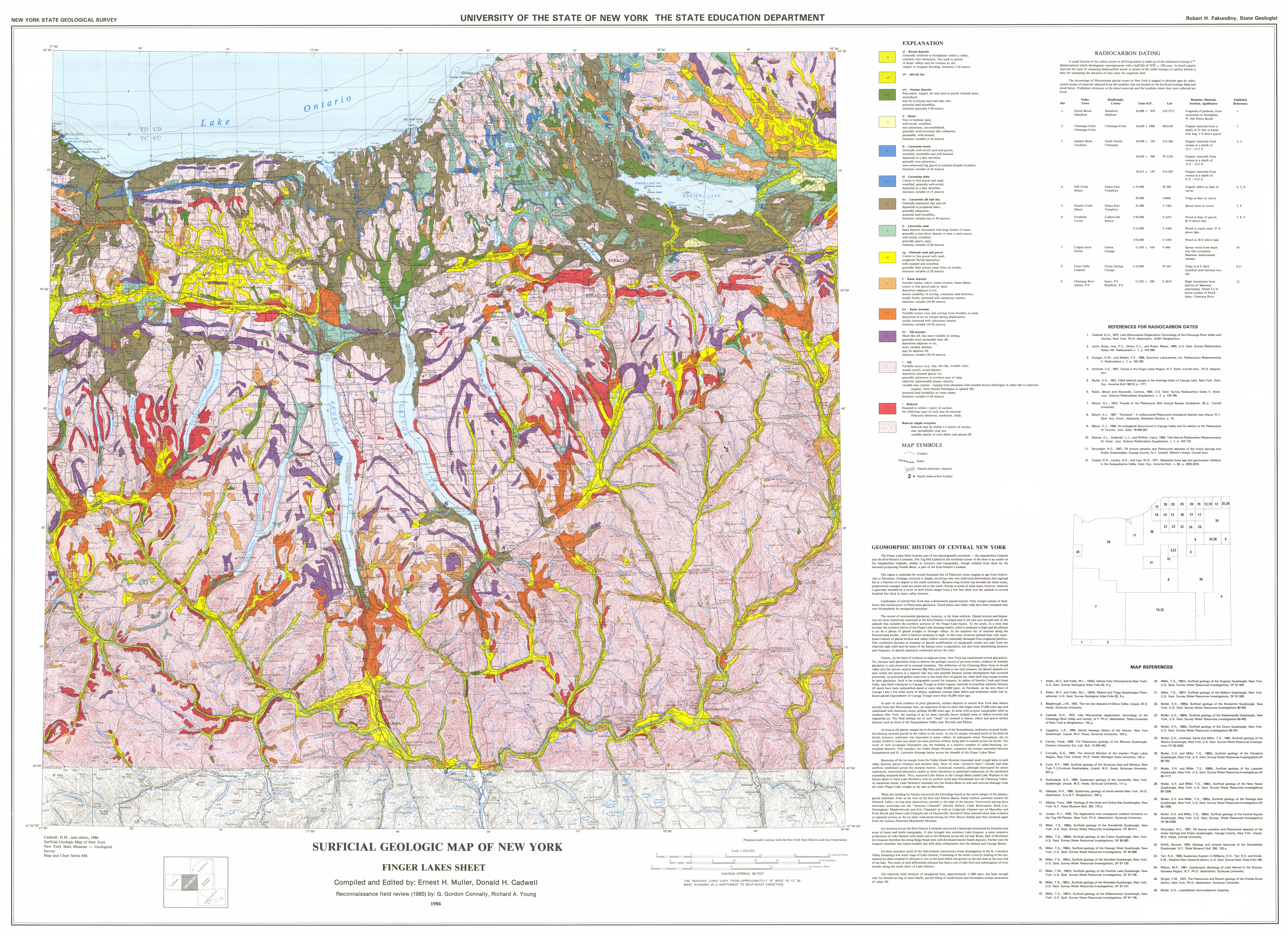
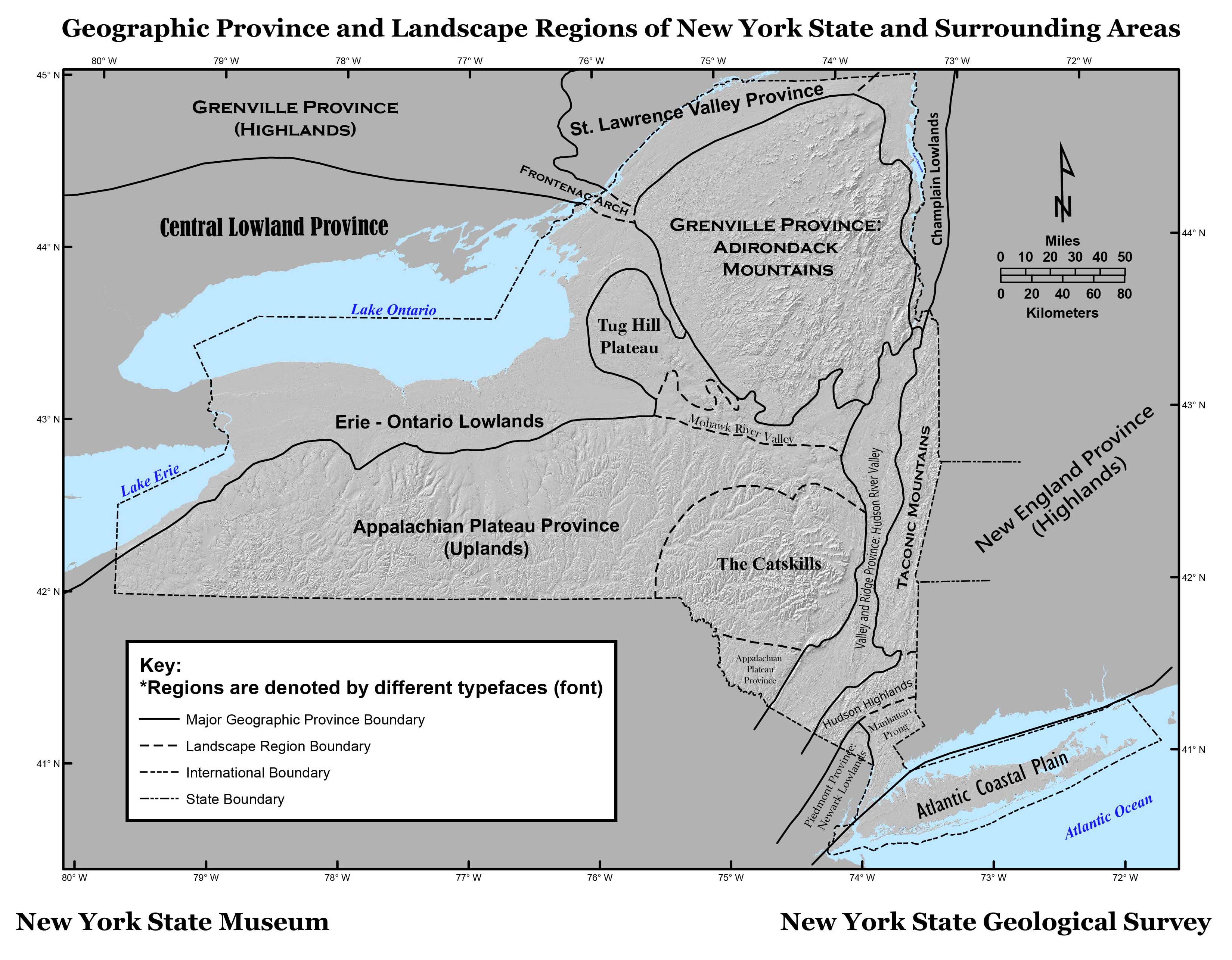
For a complete explanation, see Map & Chart Series Number 40
available from the NYS Museum Publications Department
http://www.nysm.nysed.gov
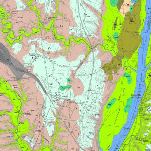
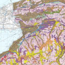
af - Artificial fill
al - Recent alluvium
Oxidized fine sand to gravel, permeable,
generally confined to flood plains within a valley,
in larger valleys may be overlain by silt,
subject to flooding, thickness 1-10 meters,
alf - Alluvial fan
Poorly stratified silt, sand, and boulders,
fan shaped accumulations,
at bottoms of steep slopes,
generally permeable, thickness 1-10 meters.
alt - Alluvial terrace
Fluvial sand and gravel,
occasional laterally continuous lenses of silt,
remnants of earlier higher flood plains,
generally permeable, thickness 1-10 meters.
b - Beach
Sand and gravel deposit at marine shorelines,
thickness variable.
co, col - Colluvium
Mixture of sediments,
deposited by mass wasting,
thickness generally 1 - 5 meters.
cof - Colluvial fan
Fan shaped accumulation,
mixture of sediments,
at mouths of gullies,
thickness generally 1 - 5 meters.
d - Dunes
Fine to medium sands,
well sorted, stratified,
generally wind-reworked lake sediment,
permeable, well drained,
thickness 1-10 meters.
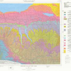
pm - Swamp deposits
Peat-muck, organic silt and sand in poorly drained areas,
unoxidized,
commonly overlies marl and lake silt,
potential land instability,
thickness 2-20 meters.
alp - Pleistocene alluvium
lb - Lacustrine beach
Generally well sorted sand and gravel,
stratified, permeable and well drained,
deposited at lake shoreline,
generally non-calcareous,
may have wave-winnowed lag gravel,
thickness variable (1-5 meters).
mb - Marine beach
Generally well sorted sand and gravel,
elevation at or below highest marine level,
permeable and well drained,
may be fossiliferous,
deposited in brackish to salt water,
thickness variable (1-5 meters).
ld - Lacustrine delta
Coarse to fine gravel and sand,
stratified, generally well sorted,
deposited at a lake shoreline,
thickness variable (3-15 meters).
md - Marine delta
Coarse to fine gravel and sand,
elevation at or below highest marine level,
stratified, generally well sorted,
deposited in brackish to salt water,
permeable, thickness variable (3-15 meters).
lsc - Lacustrine silt and clay
Generally laminated silt and clay,
deposited in proglacial lakes,
generally calcareous, low permeability,
potential land instability,
thickness variable (up to 50 meters).
sc - Undifferentiated marine and lacustrine silt and clay
Elevation within highest marine level,
generally laminated to massive silt and clay,
may include fossil shells,
deposited in brackish to salt water,
low permeability, potential land instability,
thickness variable (up to 50 meters).
ls - Lacustrine sand
Generally quartz sand, well sorted, stratified,
usually deposited in proglacial lakes,
but may have been deposited on remnant ice,
generally a near-shore deposit or near a sand source,
permeable, thickness variable (2-20 meters).
s - Undifferentiated marine and lacustrine sand
Well sorted, stratified, fine to medium sand,
generally a near-shore deposit,
at or below highest marine level,
may include fossil shells,
may be a brackish to salt water deposit,
permeable, thickness variable (2-20 meters).
d - Wind-deposited sand
Fine to medium sand,
well sorted, stratified,
generally wind-reworked lake sediments,
permeable, well drained,
thickness variable (1-10 meters).
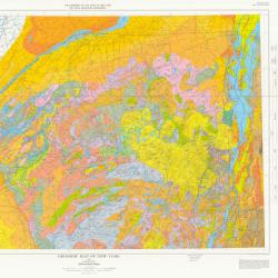
og - Outwash sand and gravel
Coarse to fine gravel with sand,
proglacial fluvial deposition,
well rounded and stratified,
generally finer texture away from ice border,
permeable, thickness variable (2-20 meters).
fds - Fluvial deltaic sand
Same as outwash sand and gravel,
except deposition further from glaciers,
age uncertain.
fg - Fluvial sand and/or gravel
Sand and/or gravel,
occasional laterally continuous lenses of silt,
deposition farther from glacier than outwash,
age and proximity to ice uncertain,
permeable, thickness variable (1-20 meters).
k - Kame deposits
Coarse to fine gravel and/or sand,
includes kames, eskers, kame terraces, kame deltas,
ice contact, or ice cored deposition,
lateral variability in sorting, texture
and permeability,
may be firmly cemented with calcareous cement,
thickness variable (10-30 meters).
ki - Inwash
Coarse to fine gravel and/or sand,
interpreted as alluvium
deposited adjacent to active or remnant ice
by streams of nonglacial origin,
thickness variable (2-20 meters).
usda - Undifferentiated stratified drift assemblage
Dominantly clay, silt and sand,
limited gravel and diamicton,
stratification includes undisturbed and deformed laminations,
ice-contact structures,
lenticular, discontinuous bodies of gravel and flow till,
may represent dead-ice, disintegration and local ice-contact lake deposits
in ice-marginal and subglacial environments.,
Thickness variable (10 - 30 meters).
ali - Alluvial inwash
Deposited between active or remnant glacier ice
and draped on adjacent valley wall,
lacks kettles, permeability varies,
thickness variable (2-10 meters).
sf - Subaqueous fan
Coarse to fine gravel and/or sand,
variable texture and sorting,
deposited adjacent to glacier with
englacial or subglacial conduit debouching in deep water,
thickness variable (5-30 meters).
km - Kame moraine
Variable texture (size and sorting) from boulders to sand,
deposition at an active ice margin during retreat,
constructional kame and kettle topography,
locally, calcareous cement,
thickness variable (10-30 meters).
tm - Till moraine
Variable texture (size and sorting),
generally low permeability,
deposition adjacent to ice,
thickness variable (10-30 meters).
ta - Ablation moraine
Till, deposited by downwasting,
with minor amounts of sand and silt,
deposition during final melting of glacier,
thickness variable (1-10 meters).
cd - Colluvial diamicton
Mixture of sediments,
unique to region beyond Wisconsinan glacial limit,
rebedded saprolite and glacial debris,
may be old (Illinoian) drift,
homogenized by varying degrees of colluviation,
bedrock may sporadically crop out or be within 1 - 3 meters of the surface.
t - Till
Variable texture (boulders to silt),
usually poorly sorted sand-rich diamict,
deposition beneath glacier ice,
permeability varies with compaction,
thickness variable (1-50 meters).
Adirondack tills: generally sand-rich diamict,
metamorphic provenance.
Ontario-St. Lawrence-Champlain tills:
generally silty clay to silt loam,
sedimentary provenance.
Tug Hill tills: generally stony silt-clay to sandy silt,
differentiated from "ta" in this region,
sedimentary provenance.
r - Bedrock
Exposed or generally within 1 meter of surface,
in some areas saprolite is preserved.


