

Annular Mounds at Perch Lake
First recorded in the mid-1850s, the unusual mounds at Perch Lake in Jefferson County, New York have long eluded satisfactory archaeological explanation. With funding from the National Science Foundation, we have been exploring some of the geoarchaeological and archaeobotanical aspects of these fascinating features.
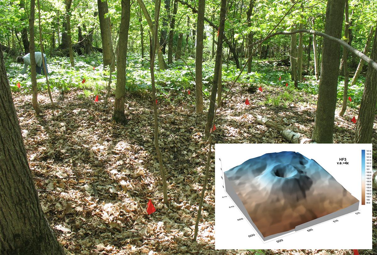
The mounds at Perch Lake are annular or ring-shaped features made of earth and stones. Recent walkover survey in the 4 x 10 km area surrounding the Perch Lake basin documents 70 mounds, making this by far the largest mound group in New York. The mounds are small and subtle, but consistently complete circles (or slight ovals). Detailed topographic surveys show that they rarely exceed a meter in height. Outer diameters average about 11 m, and the ring crests defining a central depression have an average diameter of about 5 m. There are no ditches or borrow pits associated with these mounds, and there are no other mound forms in the Perch Lake area.
First reported by Franklin Hough in an 1851 Regents Report, the Perch Lake mounds soon became the subject of much speculation and numerous excavations. They figured prominently during the formation of the Jefferson County Historical Society in 1886, attracting the attention of William M. Beauchamp, one of the pioneers of New York archaeology. In 1901 Beauchamp made several direct field observations at Perch Lake that culminated in his 1905 NYSM monograph, the last comprehensive survey of the mounds prior to the present study. Beauchamp concluded that the annular rings were the remains of ancient lodge sites, but many since have questioned this interpretation.
Over the years numerous explanations for the mounds have been offered by archaeologists. The accompanying diagram organizes these diverse interpretive strains using a schema that helps to illustrate how the Method of Multiple Alternative Hypotheses can be used in a reiterative way to work towards better explanation. P on the left is the overarching phenomenon of the Perch Lake mounds; on the right, proposed explanations are placed into three broad but not necessarily exclusive categories. R signals rejection of the hypothesis on the basis of archaeological evidence.
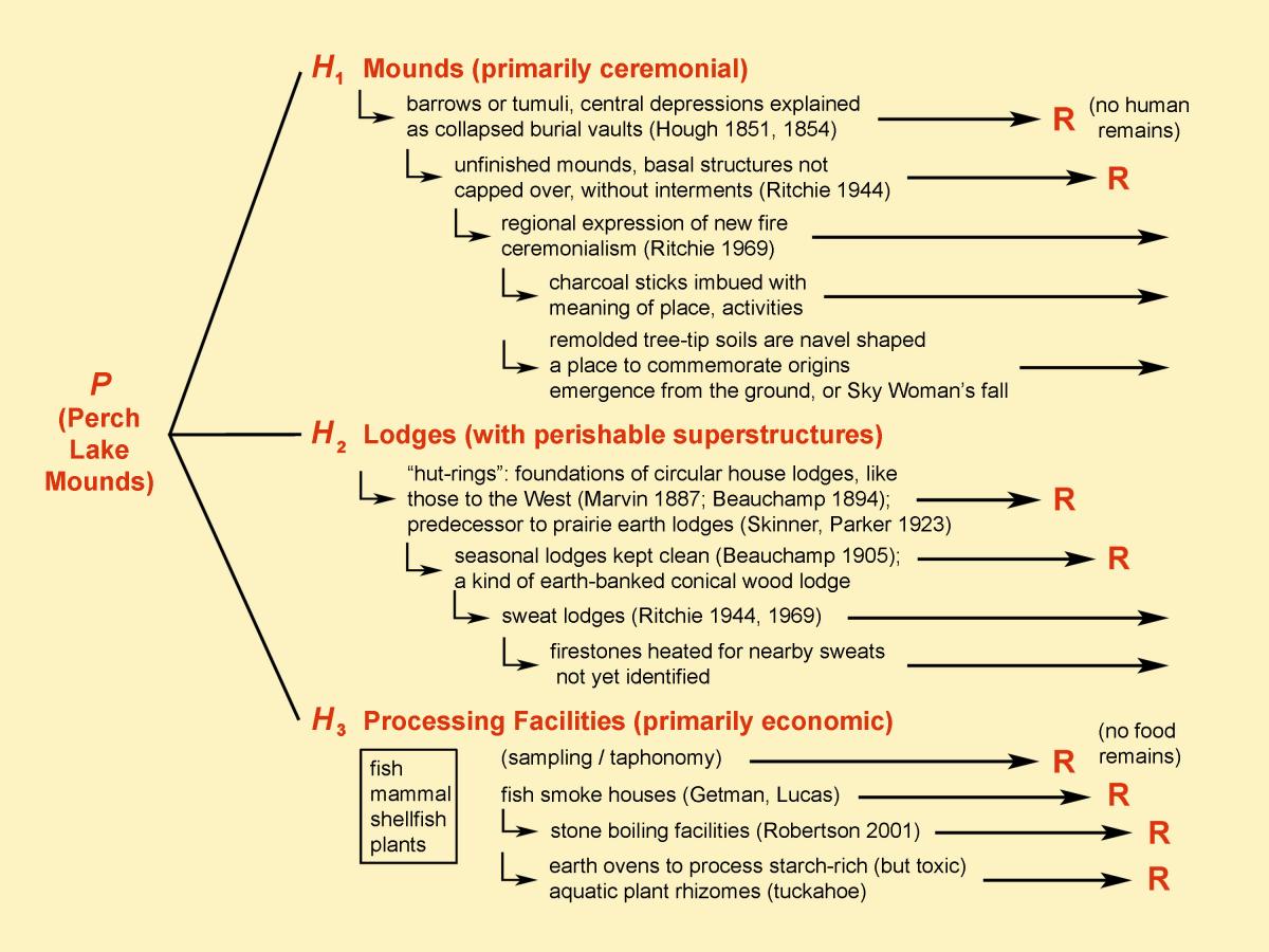
The mounds are not burial mounds or mortuary sites, as no human remains have ever been found in them. They contain much charcoal and burned rock but few other artifacts. They lack plant or animal remains expected if they were food-processing sites or habitation structures. In the present study, we are focused on conducting a field census of the mounds for preservation purposes and on gathering basic descriptive data that better documents some of the morphometric and geophysical attributes of the mounds.
Prior to this study no one had made any real attempt to look for food remains to address the suite of economic hypotheses, or to study in detail the internal structure and history of a mound. To do this, we conducted limited test excavations by working off of reopened historical excavations in two mounds on the rocky High Banks that form eastern shore of Perch Lake. No food remains were found in the newly excavated samples despite a large and intensive archaeobotanical flotation effort in the field and in the laboratory, so we reject the series of economic hypotheses, including our own favored one. This is no small gain, however, as it places exploration and refinement of the other hypotheses on firmer ground.
Stratigraphic studies show that the mounds are planned, carefully-made geometric structures of earth and stone, internally complex but with sharply delineated outer margins. A Perch Lake mound was first a made earthen structure that later became the site of many subsequent burn episodes, in which much charcoal was produced when fires were extinguished under soil or stones. Few intact burn surfaces are preserved, as the soil and stones were subsequently reorganized in an act of mound building that would leave the mound in its very distinctive form. The two tested mounds were found to have been made at the sites of tree-tip, where pit-and-knoll disturbed soils were remolded into the ring-shaped form. Near-surface soil horizons in the area that would become the mound were also used for the earthen fraction of the rings, and their excavation may have served as the initial marking out of the mound space that would be maintained with subsequent use. Sixty seven new high resolution radiocarbon dates place construction and near continuous ritual use of these mounds minimally between 50 BC and AD 1425.