

Niagara Falls
Niagara Falls is one of most popular attractions in New York and around the world. The majestic power of immense volumes of water spilling over the falls and plunging to the rocks and river below is an awesome physical and visual experience, which is rarely matched elsewhere.
Niagara is far from the highest waterfall in the world, or even in New York. However, the rush of over 6 million cubic feet of water per minute, approaching the cascade at about 25 miles per hour, and plunging 70 to 190 feet across a distance of about 3000 feet, make it one of the natural wonders of the world. The varied patterns of flow across the wall of the waters' descent easily capture your attention, and hold you almost hypnotized at times. Whether viewing from the side, the river below, or behind the falls, the experience of Niagara Falls is a powerful one, indeed.
The earliest report of Niagara Falls by Europeans (1604) comes from Samuel de Champlain on his first voyage to the New World in 1603. He traveled only as far as modern-day Montreal, but gathered information on features further upriver from Native Americans. On Niagara Falls he wrote "That there is a fall about a league wide, where a very large mass of water falls into said lake..." (translated from French; from Mason, 1921, Anthology and Bibliography of Niagara Falls).

Niagara Falls, 1698
Oldest known image of Niagara Falls, from 1698. Drawing based on a description by explorer and missionary Father Louis Hennepin. http://purple.niagara.edu/cam/Niagara/impr18c.html
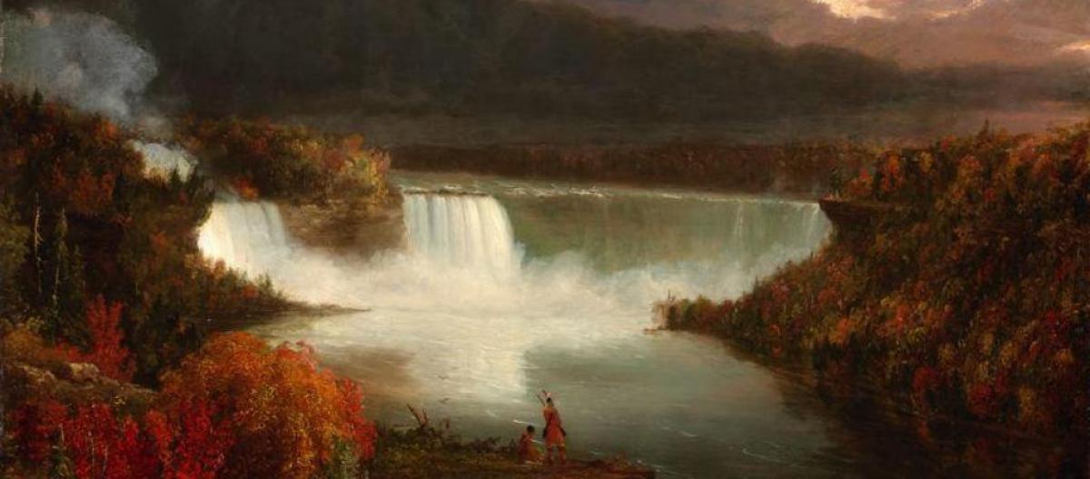
Distant View of Niagara Falls
Distant View of Niagara Falls. Painting by Thomas Cole, father of the Hudson River School of painters (oil on wood, 1830).
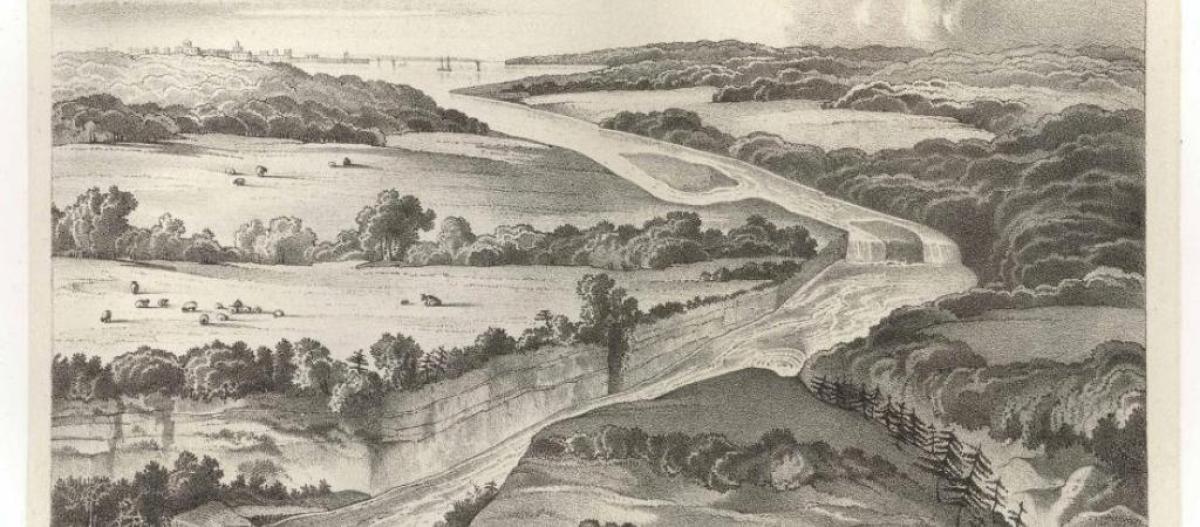
Birdseye view of Niagara Falls
Birdseye view of Niagara Falls and the surrounding country. From James Hall, 1843, The Geology of New York, Part 4, Comprising the Geology of the Fourth District. New York State Geological Survey.
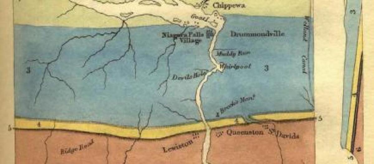
1845 View of Niagara Falls by Lyell
Birdseye View of Niagara Falls and Adjacent Country, Colored Geologically. From Sir Charles Lyell, 1845, Travels in North America, with Geological Observations. Lyell, author of The Principles of Geology (1830) is generally considered the father of modern geology. while...
The Geological Story—Basics
What you see today is not what Niagara Falls was in the past, or will be in the future. During the peak of the last great glaciation, the area of Niagara Falls was covered by over a mile's thickness of glacial ice, which blanketed the region to southern New York, northern Pennsylvania and northern Ohio. As the ice retreated from the area around 16,000 years ago, waters draining the newly gouged out Great Lakes searched along a long escarpment extending through western New York to southern Ontario and beyond, for a low place to flow over.
Approximately 12,000 years ago water found a single low pathway through the "Niagara Escarpment", and began to carve out a channel—the Niagara River. At that time, however, "Niagara Falls" was about seven miles downstream— Lewiston, NY and Queenston, Ontario. Over the last 12,000 years erosion of the resistant rocks that cap Niagara has allowed the Falls to migrate about 7 miles upstream, and form the high-walled Niagara Gorge along its former path.
Even today, Niagara Falls is estimated to be migrating upstream, on the order of one foot per year. At current rates of erosion and migration, the falls may reach softer, more easily erodible rocks (including shale and rock salt) upstream in about 15,000 years, leading to the end of a major waterfall along the Niagara River. And by some estimates, the river will erode back to Lake Erie in roughly 50,000 years, and after cutting through a second escarpment of resistant rocks (the Onondaga Limestone), it will erode through soft shales, and begin to very slowly drain Lake Erie.
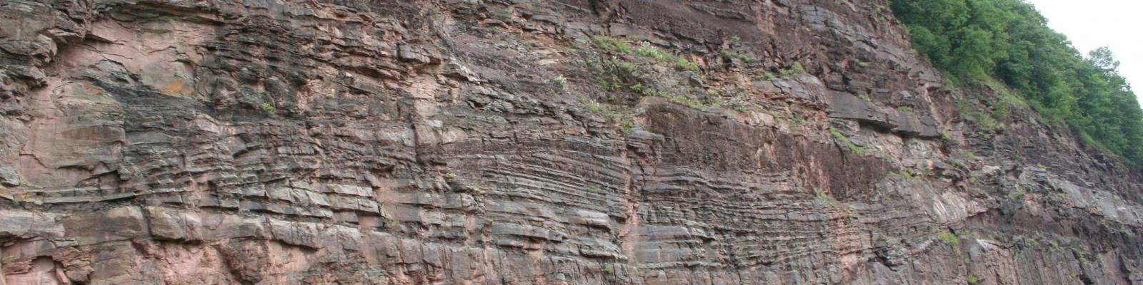
The rocks that are seen in the falls were deposited in a shallow sea that covered much of the eastern U.S. and adjacent Canada between about 440 and 425 million years ago (middle part of the Silurian geologic period). Slightly older rocks, visible downstream through the Niagara Gorge, were deposited along a coastal area, sometimes below sea level, and sometimes on land.
These sedimentary rocks, such as limestone, shale, sandstone and dolostone, are seen as distinct layers in the falls and along the gorge. Some of the rock layers, such as the soft, easily eroded Rochester Shale below the cap of Niagara Falls, contain a great diversity of marine fossils, such as brachiopods, trilobites, corals and crinoids.
The Geological Story—In Greater Depth
The Niagara Escarpment is a prominent cliff-forming escarpment that extends from western New York into southern Ontario, northward to the upper peninsula of Michigan, and then bends downward into eastern Wisconsin and Illinois. The escarpment is capped by relatively hard, resistant rocks of the Silurian-age Lockport Group (chiefly dolostones and limestones), which are underlain by less resistant rocks (shales and limestones, like the fossiliferous Rochester Shale).
The rocks visible at Niagara Falls were deposited in a shallow seaway that covered much of the eastern U.S. during the Silurian Period. Older Silurian rocks below the river level were variously deposited in shallow seas to lowlands. At the bottom of the river channel, even older red shales and sandstones of the Ordovician Period (Queenston Formation) were deposited on land, during a major fall in global sea level. An erosion surface, with a few million years of time missing, occurs at the contact of the Ordovician and Silurian rocks.
The erosional retreat of the falls upstream is slower today than in the past, largely due to withdrawal of waters from the Niagara River for hydro-electric power generation. Retreat for the last 500+ years was between three to five feet per year; the rate now is estimated to be about one foot per year. Climate change models predict drier conditions in the Great Lakes watershed in the future, potentially slowing the rate of erosion and retreat of Niagara Falls.
Acknowledgements:
Thanks to John Rozell and Angela Berti of NYS Parks, Recreation and Historic Preservation, Craig Williams (historian, NY State Museum), and W. Dickerson, for additional images.
Related Links:
There are many websites with general info about Niagara Falls. Here are links to some that focus on its geolog:
Niagara Falls Facts and Figures, from the Niagara Park Commission, Government of the Province of Ontario, Canada
http://www.niagaraparks.com/media/geology-facts-figures.html
Origins of Niagara from niagarafrontier.com:
http://www.niagarafrontier.com/origins.html
Wikipedia: http://en.wikipedia.org/wiki/Niagara_Falls
Niagara Falls geology fieldtrip article, from the 2005 Binghamton Geomorphology Symposium: http://www.geog.buffalo.edu/~rensch/binghamton/BGS%202005%20Field%20Gui…
Free Download of the old New York State Museum Bulletin on Niagara Falls: Grabau, A.W., 1901, Geology and Paleontology of Niagara Falls and Vicinity. New York State Museum Bulletin #45, 284 pages. (Note: Some interpretations and names of rock units and fossils have been revised since 1901, but Grabau's observations and other information are still valid and insightful) http://nysl.nysed.gov/uhtbin/cgisirsi/?ps=YTcPAQ6AtK/NYSL/278440094/523…
A more modern perspective on the geology of Niagara Falls is found in Colossal Cataract: The Geologic History of Niagara Falls, by I.H. Tesmer and J.C. Bastedo (1981, State University of New York Press, Albany, 219 p.). A briefer geological overview of the post-glacial and Paleozoic history of Niagara Falls and Niagara Gorge can be found in C.E. Brett and P.E. Calkin (1987, Niagara Falls and Gorge, New York-Ontario. Geological Society of America, Denver, Centennial Field Guide, p. 97-105).
Niagara Falls, NY 14303
United States