

Letchworth Gorge


Letchworth Gorge, in Letchworth State Park, is sometimes called “The Grand Canyon of the East”. Located in western New York southwest of Rochester, the gorge is best known for the nearly vertical cliffs up to 550 feet (168 meters) and higher, which bound the Genesee River.
Three large waterfalls occur within the canyon, but tens of additional falls occur along the river and along its tributaries in the park. The highest of these, Inspiration Falls, has a total drop of 350 feet (107 meters), making it the highest waterfall in New York.
Prior to 1797, the lands including Letchworth gorge belonged to the Seneca people, who called it Sehgahunda (“the vale of three falls”). White pioneers began to settle along the gorge in the early 1800s, after which two villages rose. Tourism became significant in the late 1800s. Following the origin of Letchworth State Park in 1907, an increasing larger part of the gorge and surrounding area has been added — the park now totals 14,350 acres. Since 1954, with completion of the Mount Morris dam (a major flood control project), the bottom of the gorge is periodically flooded.
Geological Features
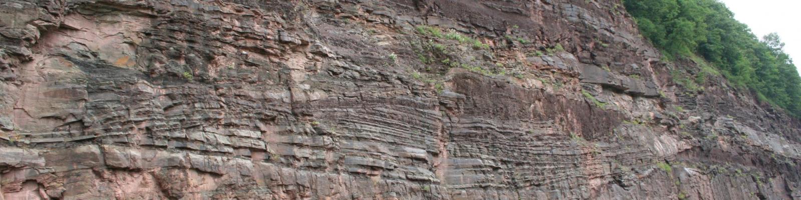
The rock seen in the walls of Letchworth gorge consist of shales, siltstones and sandstones that were deposited in a shallow sea that covered much of the eastern U.S. during the Late Devonian Period. A volcanic ash layer in shales near the Mount Morris dam, at the lower end of the gorge, has been dated at 381.1 +/- 1.3 million years old.
Rocks in the lower part of the gorge consist chiefly of black to gray shales (West River, Middlesex, Cashaqua and Rhinestreet formations). Upstream, progressively younger rocks are exposed, which feature increasing amounts of siltstone and sandstone (Angola, Gardeau and Nunda formations). The rocks exposed through Letchworth gorge were deposited as muds to sands over roughly three to five million years of time.
The physical character of Letchworth gorge varies along its length. The upper and lower sections of the gorge (see figures) are narrow and deep, cut into the bedrock. In contrast, the middle section is a still deep but broad, relatively flat bottomed valley, variously bounded along its walls by either bedrock or glacial sediments.
These differences reflect areas where the Genesee River has cut new gorges through the rock versus where it flows through an older section of gorge. The steep and narrow newer sections in the upper and lower reaches have been eroded out since glacial ice retreated from the area, prior to approximately 13,000 years ago. The middle section runs through a section of an older gorge, in which thick glacial sediments were eroded out after the last glacial retreat. Other parts of the older gorge, where the river no longer flows, remain fully to partially filled up with glacial till and lake sediments.
NY
United States